


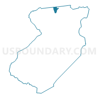
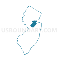
Edison township voting district 68, Middlesex County, New Jersey
About
Outline

Summary
| Unique Area Identifier | 619978 |
| Name | Edison township voting district 68 |
| County | Middlesex County |
| State | New Jersey |
| Area (square miles) | 1.30 |
| Land Area (square miles) | 1.29 |
| Water Area (square miles) | 0.00 |
| % of Land Area | 99.66 |
| % of Water Area | 0.34 |
| Latitude of the Internal Point | 40.59161250 |
| Longtitude of the Internal Point | -74.38576000 |
Maps

Graphs
Select a template below for downloading or customizing gragh for Edison township voting district 68, Middlesex County, New Jersey


Neighbors
Neighoring Voting District (by Name) Neighboring Voting District on the Map
- Edison township voting district 1, Middlesex County, NJ
- Edison township voting district 3, Middlesex County, NJ
- Edison township voting district 43, Middlesex County, NJ
- Edison township voting district 66, Middlesex County, NJ
- Edison township voting district 70, Middlesex County, NJ
- Plainfield city ward 3 voting district 4, Union County, NJ
- Scotch Plains township voting district 20, Union County, NJ
- South Plainfield borough voting district 12, Middlesex County, NJ
- South Plainfield borough voting district 3, Middlesex County, NJ
Top 10 Neighboring County Subdivision (by Population) Neighboring County Subdivision on the Map
- Edison township, Middlesex County, NJ (99,967)
- Plainfield city, Union County, NJ (49,808)
- Scotch Plains township, Union County, NJ (23,510)
- South Plainfield borough, Middlesex County, NJ (23,385)
Top 10 Neighboring Place (by Population) Neighboring Place on the Map
Top 10 Neighboring Unified School District (by Population) Neighboring Unified School District on the Map
- Edison Township School District, NJ (99,967)
- Plainfield City School District, NJ (49,808)
- Scotch Plains-Fanwood Regional School District, NJ (30,828)
- South Plainfield Borough School District, NJ (23,385)
Top 10 Neighboring State Legislative District Lower Chamber (by Population) Neighboring State Legislative District Lower Chamber on the Map
Top 10 Neighboring State Legislative District Upper Chamber (by Population) Neighboring State Legislative District Upper Chamber on the Map
Top 10 Neighboring 111th Congressional District (by Population) Neighboring 111th Congressional District on the Map
Top 10 Neighboring Census Tract (by Population) Neighboring Census Tract on the Map
- Census Tract 14.15, Middlesex County, NJ (5,420)
- Census Tract 14.13, Middlesex County, NJ (5,373)
- Census Tract 397, Union County, NJ (5,332)
- Census Tract 9.02, Middlesex County, NJ (4,618)
- Census Tract 386.02, Union County, NJ (4,002)
- Census Tract 14.11, Middlesex County, NJ (3,631)
- Census Tract 14.12, Middlesex County, NJ (3,284)
- Census Tract 10.01, Middlesex County, NJ (2,529)